LEARN THAT EXTRA SKILL. USE IT!!
Skills that sell . Results that are dependent on your effort.

- This event has passed.
Mastering GIS in both Mobile & Desktop Platforms
06/06/2022 @ 09:00 - 10/06/2022 @ 16:30 EAT
45000KES
Mastering GIS in both Mobile & Desktop Platforms
INTRODUCTION
Explore the world of spatial analysis and cartography with geographic information systems (GIS). In this geospatial class you will learn the basics of the industry’s leading software tool, ArcGIS, during our ONE week-long training.
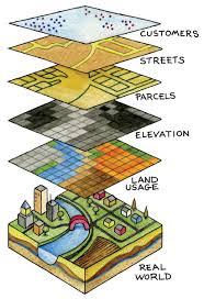
Geographical information systems, or GIS, focuses on improving existing technologies as well as developing new ones in order to collect, analyse, distribute, interpret, transform and visualise data about the surface of the earth and its geography. A good knowledge of informatics is required in order to succeed in programmes in geographical information systems. Specialised computer software is used to display detailed data about the earth’s surface
Mastering GIS in both Mobile & Desktop Platforms
VENUE: Kenvision Techniks Workshops
Registration/ Fee: KES 45K
( This fee is inclusive of Tuition, Certification, Lunch, Dinner, and drinks to be consumed during the training. Delegates to cater for their own travel & accommodation)
If you are a Researcher, planner or a land/resource manager, you can gain a basic working knowledge of Geographic Information Systems (GIS) and its terminology, and the spatial analysis skills needed to integrate field data with watershed-scale variables in enrolling for this GIS course.
Learn foundational geospatial concepts that apply to data, maps, and analysis workflows widely used for intelligence production, planning, and operations. You will gain skills in use of the ArcGIS platform as you explore techniques to efficiently visualize, create, and analyze geospatial data.
